Navigation Aids
Successful navigation with markers, buoys and beacons
The waters of the United States and its territories are marked by the U.S. Aids to Navigation System. This system encompasses buoys and beacons that conform to the International Association of Lighthouse Authorities (IALA) buoyage guidelines, as well as other short-range aids to navigation.
The U.S. Aids to Navigation System is intended for use with nautical charts. You can't know the exact meaning of a particular aid to navigation unless you consult the appropriate nautical chart. Additional, important information supplementing that shown on charts is contained in the Light List, Coast Pilots, Sailing Directions, and Reed's.
Types Of Marks
The IALA maritime buoyage guidelines apply to buoys and beacons that indicate the lateral limits of navigable channels, obstructions, dangers (such as wrecks), and other important areas or features. This system provides five types of marks: lateral marks, safe-water marks, special marks, isolated danger marks, and cardinal marks. (Cardinal marks are not now used in the United States.) Each type of mark is differentiated from other types by distinctive colors, shapes, and light rhythms.
Lateral marks are buoys or beacons that indicate the port and starboard sides of a route to be followed; they are used in conjunction with a "conventional direction of buoyage."
Generally, lateral aids to navigation indicate on which side of the aid a vessel should pass when navigable channels are entered from seaward and a vessel proceeds in the conventional direction of buoyage. Since all channels do not lead from seaward, certain assumptions must be made so the system can be consistently applied. In the absence of a route leading from seaward, the conventional direction of buoyage generally follows a clockwise direction around land masses.
Virtually all U.S. lateral marks are located in IALA Region B and follow the traditional 3R rule of "red, right, returning." In U.S. waters, returning from seaward and proceeding toward the head of navigation is generally considered as moving southerly along the Atlantic coast, westerly along the Gulf coast, and northerly along the Pacific coast. In the Great Lakes, the conventional direction of buoyage is generally considered westerly and northerly, except on Lake Michigan where southerly movement is considered as returning from sea. When the direction of "returning" is ambiguous, check your chart carefully to determine the bouyage plan. (See Fig. 1, 2.)
Preferred channel marks are aids that mark channel junctions or bifurcations and often mark wrecks or obstructions. You may normally pass preferred channel marks on either side, but their red-and-green bands indicate the preferred channel. (See Fig. 3.)
At a point where a channel divides, when proceeding in the conventional direction of buoyage, a preferred channel in IALA Region B may be indicated by a modified port or starboard lateral mark.
CAUTION: It may not always be possible to pass on either side of preferred channel aids. Always consult the appropriate chart.
NOTE: U.S. lateral aids to navigation at certain Pacific islands are located within Region A and thus exhibit opposite color significance. Port-hand marks are red with square or cylindrical shapes; starboard-hand marks are green with triangular or conical shapes.
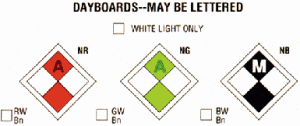
Non-lateral marks have no lateral significance but may be used to supplement the lateral aids to navigation specified above. Occasionally, daybeacons or minor lights outside of a normal channel do not have lateral significance because they do not define limits to navigable waters. These aids use diamond-shaped dayboards and are divided into four diamond-shaped sectors. The side sectors of these dayboards are colored white; the top and bottom sectors are colored black, red, or green as the situation dictates.
Safe-water marks indicate fairways, midchannels, and offshore approach points that have unobstructed water on all sides. You can use the latter when making a landfall. Safe-water marks are red-and-white striped and, if not a spherical buoy, have a red spherical topmark to further aid in identification. If lighted, they display a white light with the characteristic Morse code "A."
Isolated danger marks are erected on, or moored above or near, an isolated danger that has navigable water all around it. Don't approach these marks closely without special caution. (See Fig. 4.) Isolated danger marks are colored with black-and-red bands and, if lighted, display a group flashing (2) white light. A topmark consisting of two black spheres, one above the other, is fitted for both lighted and unlighted marks. (See Fig. 5.)
Special marks don't assist in navigation, but rather alert you to a special feature or area. The feature should be described in a nautical document such as a chart, Light List, Coast Pilot, or Notice to Mariners. Some types of areas marked by these aids are spoil areas, pipelines, traffic separation schemes, jetties, anchorages. or military exercise areas. Special marks are yellow and, if lighted, display a yellow light. (See Fig. 6.)
Information and regulatory marks alert the mariner to various warnings or regulatory matters. These marks have orange geometric shapes against a white background. The preferred channel meanings associated with the orange shapes follow:
- An open-faced diamond signifies danger.
- A diamond shape with a cross centered within indicates that vessels are excluded from the marked area.
- A circular shape indicates that certain operating restrictions are in effect within the marked area.
- A square or rectangular shape contains directions or instructions lettered within the shape. (See Fig. 7.)
Buoys are floating aids. They are moored to the seabed by concrete sinkers with various lengths of chain or synthetic rope connecting them to the buoy body.
Buoy positions represented on nautical charts are in approximate positions only because of the practical limitations of positioning and maintaining buoys and their sinkers in precise geographical locations. The Coast Guard normally verifies buoy positions during periodic maintenance visits. Between visits, atmospheric and sea conditions, seabed slope and composition, and collisions or other accidents may cause buoys to sink, capsize, or shift from their charted locations.
Buoy moorings vary in length. The length defines a "watch circle," within which buoys can move. Watch circles are not indicated by the symbols representing buoys on charts.
CAUTION: Attempting to pass a buoy close aboard risks collision with a yawing buoy or with an obstruction that the buoy marks. Don't rely on buoys alone to determine your position because buoy reliability is limited. Prudent mariners use bearings from fixed aids to navigation and shore objects, soundings, and various methods of electronic navigation to positively fix their position.
Beacons are permanently fixed to the earth's surface. They range from lighthouses to small unlighted daybeacons that exhibit a daymark to make them readily visible and easily identifiable against background features. The daymark conveys, during daylight hours, the same significance as a light at night. (See Fig. 8.)
CAUTION: Don't pass fixed aids to navigation close aboard; doing so may put you in danger of collision with riprap or structure foundations, or with the obstruction or danger being marked.
| Characteristic | Port-Hand Marks | Starboard-Hand Marks |
|---|---|---|
| Color | Green | Red |
| Shape (buoys) | Cylindrical (can) or pillar | Conical (nun) or pillar |
| Dayboard or Topmark when (fitted) | Green square or cylinder | Red triangle or cone point Upward |
| Light Color (When Fitted) | Green | Red |
| Reflector Color | Green | Red |
| Numbers | Odd | Even |
| Characteristic | Preferred channel to starboard | Preferred channel to port |
| Color | Green with one broad red band | Red with one broad green band |
| Shape (buoys) | Cylindrical (can) or pillar | Conical (nun) or pillar |
| Dayboard | Green square, lower half red | Red triangle, lower half green |
| Topmark (when fitted) | Green square or cylinder | Red triangular cone |
| Light (when fitted) Color | Green | Red |
| Rhythm | Composite group flashing (2+1) | Composite group flashing (2+1) |
| Reflector Color | Green | Red |
Reporting Defects In Aids To Navigation
The Coast Guard can't keep the thousands of aids to navigation comprising the U.S. Aids to Navigation System under simultaneous and continuous observation and can't keep every aid to navigation operating properly and on its assigned position at all times. Therefore, for the safety of all mariners, promptly report to the nearest Coast Guard unit any aid to navigation that is either off station or exhibiting characteristics other than those listed in the Light List. Prefix radio messages "COAST GUARD" and transmit them directly to one of the U.S. government radio stations listed in Reed's Nautical Almanac.
Recommendations and requests pertaining to aids to navigation and reports of navigation aids that are no longer needed should be mailed to the appropriate Coast Guard district. (See Fig. 9.)
Local Notice to Mariners are published weekly by each Coast Guard District and contain the latest information about special warnings, changes to aids to navigation, and more. If you would like to receive the LNM for your district, contact the appropriate office listed below. Web: http://www.uscg.mil
First District
408 Atlantic Avenue
Boston, MA 02110-3350
(617) 223-8600
Eighth District
Hale Boggs Federal Building
501 Magazine Street
New Orleans, LA 70130-3396
(504) 589-6245
Ninth District
1240 East 9th Street
Cleveland, OH 44199-2060
(216) 522-3826
Fifth District
Federal Building
431 Crawford Street
Portsmouth, VA 23704-5004
(757) 483-8562
Seventh District
Brickell Plaza Federal Building
909 SE 1st Avenue, RM. 406
Miami, FL 33131-3050
(305) 536-5654
Eleventh District
Building 51-5
Coast Guard Island
Alameda, CA 94501-5100
(510) 437-2904
Thirteenth District
Jackson Federal Bldg
915 Second Avenue
Seattle, WA 98174-1067
(206) 220-7105
Fourteenth District
Prince Kalanianaole Fed. Bldg.
9th Floor, Room 9139
300 Ala Moana Blvd.
Honolulu, HI 96850-4982
(808) 541-2121
Seventeenth District
P.O. Box 25517
Juneau, AK 99802-5517
(907) 463-2065
Night: 907-463-2000
NIMA Notice to Mariners The National Imagery and Mapping Agency also publishes a weekly Notice to Mariners which includes most aids and charts as well as international notices.
Canadian Notice to Mariners are now published monthly, one edition for the West Cast and another for the East Coast. You may obtain either edition by contacting the Director General, mariner Navigation Services Directorate, Canadian Coast Guard, Ottawa, Ontario, K1A ON7, (613) 998-1574